Published in Norwegian in Bergens Tidende 29.03.2015
The Barents Sea has for a long time been an area of great interest for exploration and exploitation. With declining sea ice extent, associated with climate change, the area will most likely experience a further increase in economic activities related to fisheries, tourism, and oil. The Barents Sea, however, is also the home to extreme weather due to the close proximity of air masses situated over cold sea ice and relatively warm oceans.
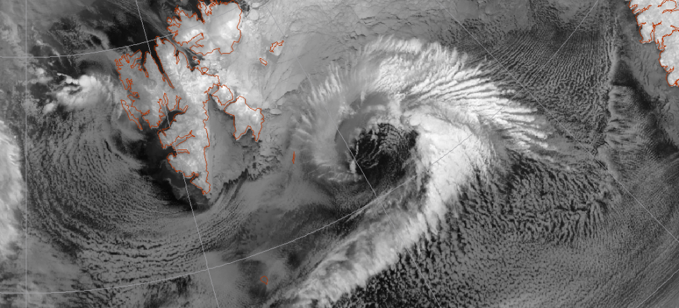
This contrast in temperature can give rise to severe storms, such as polar lows, which are severe low-pressure systems with Hurricane strength winds over open water located in the polar areas. For centuries, these storms have brought fatalities and ship wreckage to coastal communities and marine activities in northern Norway.
Meteorologists have discussed the underlying physical processes involved in polar low development for many decades now and concluded that the development comprises a complex interplay between horizontal temperature contrasts, energy released from cloud and rain formation, and energy input from the sea surface. Horizontal temperature contrasts can be seen as a source of energy, because nature always tries to even out contrasts whereby energy is converted, which can be used to fuel the wind speed in polar lows. The energy input from the sea surface is also critical for polar lows, as the sea surface temperatures in the Nordic Seas are relatively mild in winter compared to the air masses residing over the ice in the vicinity.
Thus, when cold air masses are pushed out over the sea, there will be a large contrast between the sea surface temperature, which is around 3-6 degrees Celsius and the air temperature, which can be as less as -20 degrees Celsius when it originated from the sea ice. The cold air is then heated and this energy will be partly available for the polar low to develop its gale-force winds.
While the cold air moves over the ocean, it also takes up moisture resulting in rain and cloud formation, which is also related to energy conversion that adds energy to the polar low. One has to just think of how much energy it takes to boil water until it is completely evaporated. When you consider how much energy it would take to evaporate the rain of a polar low, then you know how much energy the polar low can obtain when the water condenses in the clouds of the polar low, because the energy needed to evaporate the water will be equal to the energy you gain when water vapor is condensed again. In total, the energy accumulated in a polar low can be estimates to be roughly 1018 Joule.
This is an enormous amount of energy, which is approximately equivalent to 2 years of total annual electricity production in Norway in 2012 and of same magnitude as the energy of the severe earthquake that triggered the tsunami in eastern Japan in 2011 and caused the Fukushima incident.
A big problem in researching and forecasting polar lows, however, is that meteorologists are not quite sure about the relative importance of each of the processes mentioned above. This makes it very challenging to assess the energy and thus intensity a polar low might obtain. Another complication is to precisely predict the path of polar lows, which is essential in order to warn coastal communities along the Norwegian coast or people involved in fisheries and other marine and offshore activities.
A recent study at the Geophysical Institute, University of Bergen and the Bjerknes Centre for Climate Research presented the influence of moisture and temperature contrasts on the development of polar lows. The researchers found that the development of polar lows is very sensitive to the moisture and temperature contrasts, where polar lows will become fiercer with higher moisture amounts and larger temperature contrasts. When it comes to forecasting the paths of polar lows, MET Norway has introduced a so-called ensemble prediction system for polar lows, which predicts the probability of a polar low to hit a certain area. Another big challenge remaining is the influence of the sea surface.
In order to address some of these complex issues related to polar weather and climate, a group of international scientists met 23-27 March for a scientific workshop in Rosendal, organized by researchers from the Geophysical Institute, University of Bergen and the Bjerknes Centre for Climate Research.
Interestingly, some recent studies have claimed that there will be less polar lows in the future with declining sea ice extent. However, as economic exploration will seek its boundaries, exploration and fishing will likely follow the ice edge and thus the area prone to polar lows. Furthermore, new shipping routes, such as the Arctic East and Northwest Passage, will also tend to be near the ice edge and hence exposed to severe weather such as polar lows. It will therefore remain important to improve our understanding and forecasting capabilities of polar lows.